Implemented scalable deep learning workflows on AWS using Petastorm and TensorFlow, enabling efficient training on Bigearthnet dataset.
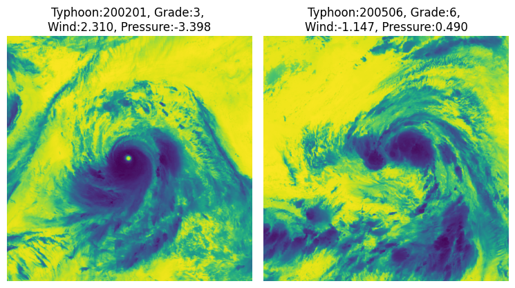
Developed a multitask regression pipeline using ResNet50 to predict multiple continuous targets simultaneously from image data
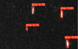
Developed a deep learning workflow for detecting ships in SAR imagery, comparing 3 different deep learning models.
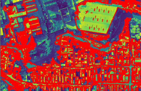
Activity3: Applied tree-based algorithms for image analysis to efficiently detect large building structures in remote sensing imagery.
Implemented scalable machine learning workflows on AWS using Apache Spark to process and analyze Fractal datastet efficiently
This project develops a machine learning workflow for a supervised regression task.
This project develops a GUI within eCognition to facilitate object-based time series analysis for detecting agricultural land cover changes.
PySARFlow is an open-source Python library designed to streamline the preprocessing of Synthetic Aperture Radar (SAR) data.
This project utilizes Digital Earth Africa’s STAC catalog to assess wetland dynamics in the Zambezi Delta, Mozambique.
This project involved designing and implementing a spatial database backend for a WebGIS application supporting a city festival.
This project highlights the use of cloud-based platforms for big data analytics in Earth Observation.
This project focuses on designing a Spatial Data Infrastructure (SDI) to integrate and visualize gender-disaggregated employment data across Austria.
This project employs Object-Based Image Analysis (OBIA) to assess building density patterns, focusing on the Kakuma refugee camp in Kenya.
This project applies Interferometric Synthetic Aperture Radar (InSAR) using Sentinel-1 data to assess ground deformation.
This project applies object-based image analysis (OBIA) in eCognition to move beyond traditional pixel-based methods.